FlatGeobufデータ構造解析
FlatGeobuf 公式の「Observable Notebook」より以下のファイルをDL。
公式READMEによると、FlatGeobufのデータ仕様は以下のみ。
- MB: Magic bytes (0x6667620366676201)
- H: Header (variable size flatbuffer)
- I (optional): Static packed Hilbert R-tree index (static size custom buffer)
- DATA: Features (variable size flatbuffers)
0x6667620366676201はb"fgb\x03fgb\x01"
一方、UScounties.fgbはb"fgb\x03fgb\x00"なので末尾1byteだけ違う…。
The fourth byte in the magic bytes indicates major specification version.
The last byte of the magic bytes indicate patch level.
Patch level is backwards compatible so an implementation for a major version should accept any patch level version.
ということは、UScounties.fgbはv3.0のFlatGeobufファイルであると。
後方互換があるので、v3.xの間は一貫性が保証される。
Magic bytesに続く4byte(b"\xdc\x02\x00\x00")はHeaderデータのデータ長?
header.fbsを取得し、Python向けにコンパイル。
flatc --python header.fbs
コンパイルすると以下のファイルが作成される。
-
FlatGeobuf/__init__.pyColumn.pyColumnType.pyCrs.pyGeometryType.pyHeader.py
Python内でヘッダーを読んでみる。
>>> import FlatGeobuf.Header
>>> data = open("UScounties.fgb", "rb").read()
>>> header = FlatGeobuf.Header.Header.GetRootAs(data, 12) # 8 + 4 ?
>>> header.Name()
"UScounties"
>>> header.EnvelopeLength()
4
>>> header.Envelope(0)
-179.14733999999999
>>> header.Envelope(1)
17.884812999999998
>>> header.Envelope(2)
179.77847
>>> header.Envelope(3)
71.3525606439998
>>> header.GeometryType()
6
>>> header.HasZ()
False
>>> header.HasM()
False
>>> header.HasT()
False
>>> header.HasTm()
False
>>> header.FeaturesCount()
3221
>>> header.IndexNodeSize()
16
>>> header.Title()
>>> header.Description()
>>> header.Metadata()
>>> crs = header.Crs()
>>> crs.Org()
b'EPSG'
>>> crs.Code()
4269
>>> crs.Name()
b'NAD83'
>>> crs.Description()
>>> crs.Wkt()
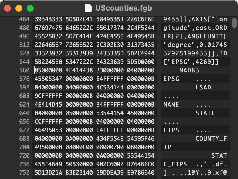
b'GEOGCRS["NAD83",DATUM["North American Datum 1983",ELLIPSOID["GRS 1980",6378137,298.257222101,LENGTHUNIT["metre",1]]],PRIMEM["Greenwich",0,ANGLEUNIT["degree",0.0174532925199433]],CS[ellipsoidal,2],AXIS["latitude",north,ORDER[1],ANGLEUNIT["degree",0.0174532925199433]],AXIS["longitude",east,ORDER[2],ANGLEUNIT["degree",0.0174532925199433]],ID["EPSG",4269]]'
>>> crs.CodeString()
>>> header.ColumnsLength()
6
>>> c = header.Columns(0)
>>> c.Name()
b'STATE_FIPS'
>>> c.Type()
11
>>> c.Title()
>>> c.Description()
>>> c.Width()
-1
>>> c.Precision()
-1
>>> c.Scale()
-1
>>> c.Nullable()
True
>>> c.Unique()
False
>>> c.PrimaryKey()
False
>>> c.Metadata()
>>>
以下の形式でパースしても問題がないので、0x2dcはヘッダーデータ長っぽい。
>>> header = FlatGeobuf.Header.Header.GetRootAs(data[12:12+0x2dc], 0)
QGIS 3.16で読んだ場合の地物数と列名が一致するので問題なさそう。
データを眺めてみると、header.Columns(0)のフィールド値がヘッダーデータの末尾の方にあり、header.Columns(5)のフィールド値がヘッダーデータの前方寄りにある逆転状態なことに気がつく。
これがFlatBuffersのデータ格納オーダーらしい。
header.IndexNodeSize()が16なので、header.fbsの定義によると、OptionalなHilbert R-Treeインデックスを持っている…?
index_node_size: ushort = 16; // Index node size (0 = no index)